Dovepass is a research prototype developed to assist drone pilots in determining the legality of specific flight paths, with an initial focus on the complex urban environment of San Francisco. The tool functions by allowing users to input a takeoff point, a destination, and specific drone specifications—such as weight, battery capacity, and maximum speeds. It then cross-references this data against a variety of constraints, including FAA airspace permissions, temporary no-fly zones, and local restrictions for areas like San Francisco city parks, the Presidio, and the Golden Gate Bridge.
The system operates by synthesizing multiple data layers to provide a 'flight check.' It utilizes a full-city OpenStreetMap extract for building data, a USGS 3DEP elevation model for terrain, and daily mirrors of FAA UAS Facility Maps and temporary flight restrictions (TFRs). For example, the tool calculates whether a drone can maintain a clear path under 400 feet above ground level (AGL) while accounting for wind resistance and battery endurance. If a route is deemed a 'no-go' due to these factors, the tool identifies the specific reason, such as a violation of a local park rule or an airspace restriction. For valid routes, it can generate printable flight cards and map files compatible with various drone applications.
Despite its comprehensive data integration, Dovepass is explicitly framed as a research prototype and does not provide official flight authorization. The tool has specific limitations: it does not monitor live air traffic, such as helicopters or other drones, and it cannot verify private property permissions or filming permits. Furthermore, while it checks for many local rules, it notes that certain areas, like the Port of San Francisco, may have property maps that are not fully machine-readable. Pilots are instructed to use the tool as a planning aid and must still perform their own mandatory pre-flight checks, such as confirming weather conditions and maintaining a visual line of sight, as required by FAA Part 107 regulations.
One critical regulatory nuance the tool helps navigate is the distinction between AGL and Mean Sea Level (MSL) altitudes. Because the FAA's standard 400-foot limit is measured from the ground directly beneath the drone, terrain changes can complicate compliance. For instance, a drone flying over a mountain might show a high MSL altitude on a controller while remaining within the legal AGL limit. Conversely, flying over a valley from a high starting point can make it difficult to stay below the 400-foot AGL ceiling. Dovepass assists in these calculations by incorporating terrain data to help pilots understand these elevation-based constraints.
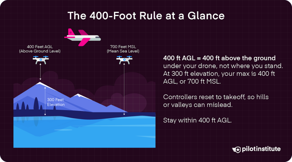
This diagram explains the technical distinction between AGL and MSL altitudes, which is a core calculation Dovepass handles to ensure regulatory compliance over varying terrain.
Additionally, the tool accounts for the 'structure exemption' for Part 107 licensed pilots. This rule allows pilots to fly up to 400 feet above a structure if they remain within a 400-foot radius of that structure. Dovepass incorporates building heights into its checks to help pilots understand where these exemptions apply. However, the tool remains a snapshot of data; because building data and temporary restrictions are refreshed at different intervals, pilots are encouraged to verify the most current information directly with the FAA or local authorities before every flight.
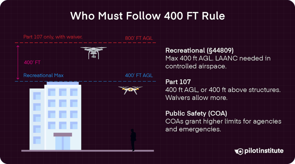
This infographic supports the discussion of Part 107 structure exemptions and the general 400-foot limit mentioned in the article.